
Plan a 6 km Admiralty Point walk in Belcarra, with the Woodhaven bridge closure and Sasamat stair detour.
Is Admiralty Point a good late October day trip? Yes, if you want a shoreline walk in forest rather than a swim day at Sasamat Lake. Metro Vancouver describes the park, officially named together with the Tsleil-Waututh place name, as a place to discover intertidal life, hike through tall trees, or swim in Sasamat Lake. The December 2022 brochure lists Admiralty Point Trail as 6 km return, about 1.5 hours to Admiralty Point and about 2 hours to Burns Point, with some sections on rocky shoreline and views of Burrard Inlet. It is graded intermediate. For late October 2026, the park is open 7 a.m. to 7 p.m. until November 2, then 7 a.m. to 6 p.m. from November 3. Admiralty Point Trail itself was not on the closure list when we checked on Oct. 21. Other trails and washrooms were.
Snapshot
| Piece | What to plan | | --- | --- | | Where | The park spans Belcarra, Anmore and Port Moody. Use the Google map link on the Metro Vancouver park page. | | Hours | 7 a.m. to 7 p.m., October 6 to November 2. 7 a.m. to 6 p.m., November 3 to December 31. The brochure says the park opens at 7 a.m., hours are posted at entrances, and gates lock when it is closed. | | Main walk | Admiralty Point Trail, 6 km return. About 1.5 hours to Admiralty Point, about 2 hours to Burns Point. Intermediate, with rocky shoreline. | | Not this walk | Woodhaven Swamp Loop is 1.2 km and gentle, but a storm damaged bridge is closed, so the loop cannot be finished. | | Lake loop | Sasamat Lake Loop is 3.2 km return. Stairs are being replaced. A detour is signed. The alert says the work should take about two weeks. | | Dogs | Leashed. Banned at White Pine Beach, on the Floatwalk swimming and fishing decks, and at most pocket beaches on Sasamat Lake. | | Washrooms | Picnic area washrooms (near the ocean) and White Pine Beach washrooms are closed until further notice. Portable toilets are out. Drinking water is at the picnic shelters. | | Fire rating | Listed as moderate when we checked on Oct. 21. Check the park page the day you go. |
Why Admiralty Point, not the lake beach
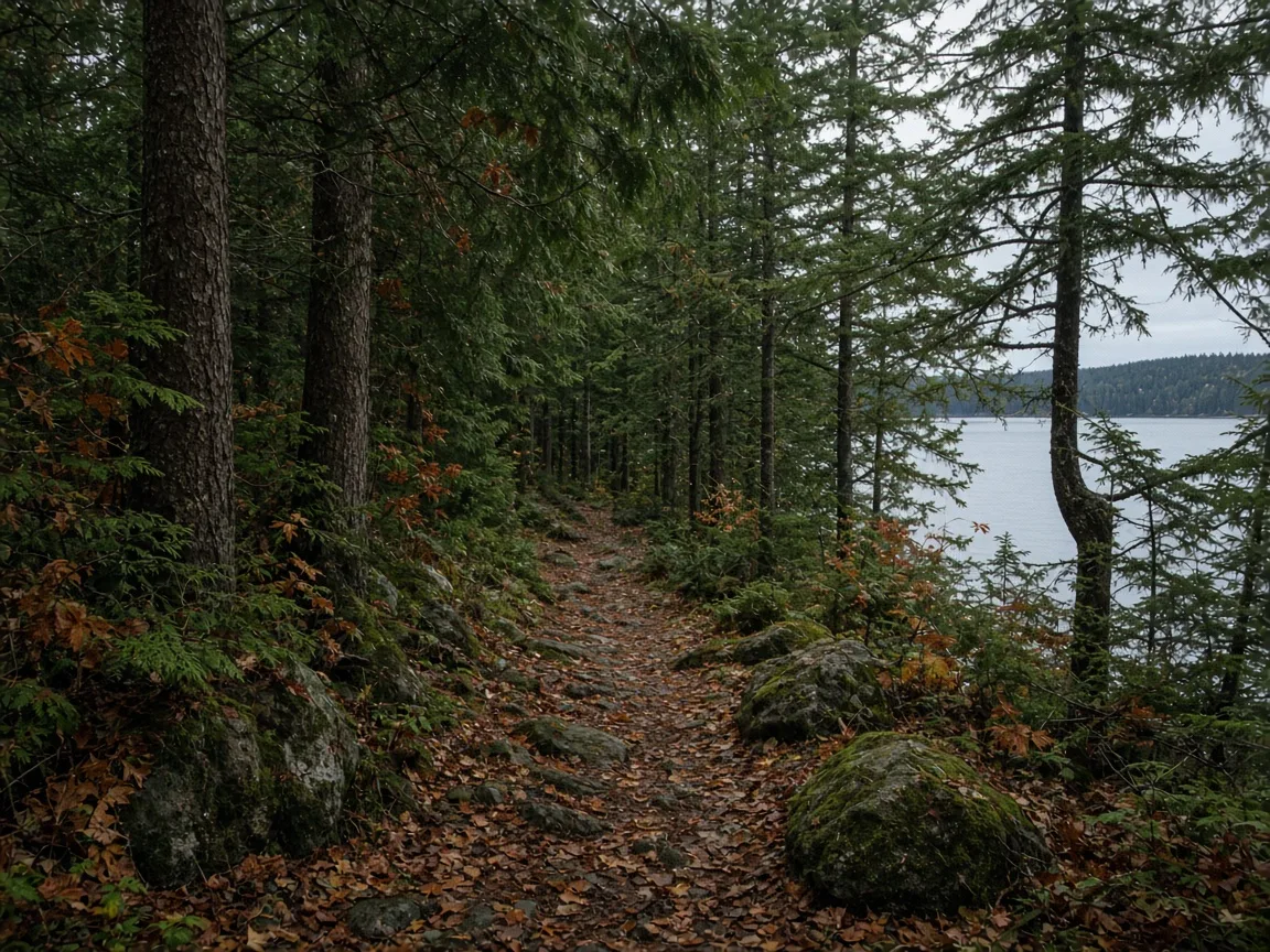
The lake is the busy picture of this park. Admiralty Point is the quieter job: an intermediate trail with inlet views, not a beach afternoon. The brochure says some sections follow rocky shoreline, with views of Burrard Inlet.
The park is not mostly closed. Four notices were on the park page on Oct. 21, 2026, and none of them names Admiralty Point Trail. You can still walk it. You should not assume the Woodhaven loop or the usual Sasamat stairs are intact, and you should not count on the built washrooms.
Metro Vancouver and səlilwətaɬ (Tsleil-Waututh Nation) are also co-developing a 20 year plan for the Admiralty Heights subarea. That is a planning process on the park page. It is not listed as a trail closure.
Getting there
Driving. Use the Google map on the park page. The brochure says seasonal pay parking started in 2021. On sunny summer days the lots at White Pine Beach and the Belcarra Picnic Area often fill early. There is no parking on Bedwell Bay Road. Late October is not that summer crush, but the parking rules still apply. This guide does not invent a fee.
On foot, bike or bus. The brochure says that if you want to avoid a full lot, arrive early or come by foot, bicycle or bus. The park page lists transit as a feature. This guide does not copy a route number, because the expanded transit note was not in the text we could read on Oct. 21. Use TransLink Trip Planner the morning you go. A separate Trends Today guide covers the Moody Centre bus day in more detail: Belcarra Regional Park day trip by transit.
Bikes on trails. Cycling is permitted on Springboard Trail. Sugar Mountain, Saddle Ridge and Bear Claw trails are open to cyclists but are rugged and steep. Cyclists yield to pedestrians. Admiralty Point Trail is listed with the hiking table, not as a cycling route. Stay on designated trails.
Half-day outline
- Start from the picnic area side if the inlet is the point of the day. The brochure describes Admiralty Point as rocky shoreline and Burrard Inlet views. Picnic shelters each seat 75 people. To book one, the brochure lists 604-432-6352. Washrooms at that picnic area, near the ocean, are closed for repairs until further notice. Portable toilets are available, and drinking water is at the picnic shelters.
- Walk Admiralty Point Trail. Plan 6 km return. Allow about 1.5 hours to reach Admiralty Point, or about 2 hours if you continue toward Burns Point. It is intermediate: some steep or rough sections, not the easy lake loop.
- Skip the broken Woodhaven loop. The easy Woodhaven Swamp Loop is 1.2 km and about 30 minutes when it is intact. On Oct. 21 a bridge on that loop was closed after storm damage. You cannot complete the loop. Retrace your steps or pick another trail. Follow the signs.
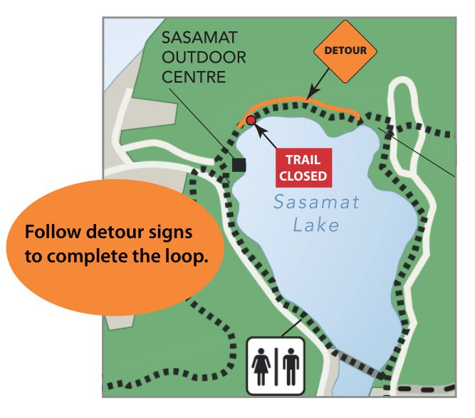
- Treat Sasamat as optional. The lake loop is 3.2 km and about 1 hour when the path is whole. The Oct. 21 alert says stairs damaged by a tree are being replaced, a detour is in place for people who still want a loop, and the work is expected to take about two weeks. The notice does not give a start date. The official map says to follow detour signs. White Pine Beach washrooms stay closed until further notice, with portable toilets available.
- Leave before the gate. The brochure says gates are locked when the park is closed.
Current alerts
These are the four Belcarra notices on the Metro Vancouver alerts page on Oct. 21, 2026.
Woodhaven Swamp Loop bridge, high. Storm damage closed a bridge. Visitors cannot complete the loop. Follow the signs, pick another route, or be ready to turn around. No end date is printed on the notice.
Sasamat Lake Loop stairs, moderate. Work is underway to replace stairs damaged by a tree. It is expected to take about two weeks. A detour lets people still make a loop. Follow the signs. The map with the alert is dated October 2026.
Picnic area washrooms, low. Washrooms near the ocean are closed for repairs until further notice. Portable toilets are available. Drinking water is at the picnic shelters.
White Pine Beach washrooms, low. Closed until further notice because of ongoing trouble repairing the water system. Portable toilets are available.
Fire rating. The park page showed moderate when we checked. The brochure says fires are only permitted in the designated fire ring at the Belcarra Picnic Area shelters, and that hot weather can add restrictions. Recheck the rating the day you go. Report wildfires to 911. The park page lists 604-432-6350 for more fire information.
Dogs, wildlife and park rules
- Dogs must be leashed. Scoop the poop into the dog waste bins. Dogs are prohibited at White Pine Beach, on the swimming and fishing decks of the Floatwalk, and at most pocket beaches along Sasamat Lake. To walk the lake loop without White Pine Beach, follow the Beach By-Pass.
- The brochure says the park has extensive bear and cougar habitat. If you meet one, stay calm and back away slowly. Do not approach, feed, or leave garbage or unattended food.
- No shellfish harvesting. The brochure says Burrard Inlet and Indian Arm are closed to clam, mussel and oyster harvesting.
- Lake fishing needs a B.C. non-tidal angling licence. Ocean fishing and crab fishing need a federal tidal licence. The brochure says only male crabs may be harvested, and that undersized and female crabs are illegal. It lists Fisheries and Oceans Canada at 604-666-2828 and a violator line at 1-800-465-4336. Confirm the current rules. This guide does not restate size limits.
- Swim at your own risk. There are no lifeguards, including at Sasamat Lake.
- Canoes and kayaks are allowed on Sasamat Lake, and paddle craft can reach Belcarra Bay from the picnic area. Launching at either spot can mean carrying the boat up to 200 metres from the parking lot. The brochure says to know tides, currents and weather.
- Liquor, cannabis and camping are not permitted. Smoking is limited to signed areas, which allow tobacco and e-cigarettes, not cannabis. Vegetation removal is prohibited.
- Belcarra Beach has intertidal life. The brochure points to beach etiquette signs and to Belcarra Beachkeepers at 604-520-6442.
Accessibility
The brochure says all park washroom buildings are wheelchair accessible, and that at the picnic area the shelters, wharf and floats are wheelchair accessible. White Pine Beach has an accessible terrace and picnic tables. Those built washrooms are the ones closed for repairs right now, so the accessible fixture you find may be a portable toilet. Check the signs when you arrive. This guide does not claim that Admiralty Point Trail itself is wheelchair accessible. The brochure grades it intermediate, with rocky shoreline.
Pairing ideas
Other still-current guides on Trends Today:
- Belcarra Regional Park day trip by transit for the Moody Centre bus plan and the lake loops
- Minnekhada Regional Park day trip for a Coquitlam marsh and lodge walk
- Port Moody day trip for the nearest town waterfront
Sources
- Metro Vancouver: the Belcarra regional park page (hours, fire rating, alerts, Admiralty Heights planning note, name history)
- Metro Vancouver: Park alerts and notices (Woodhaven bridge, Sasamat stairs, picnic and White Pine washrooms, checked Oct. 21, 2026)
- Metro Vancouver: Sasamat Lake Loop stair map, October 2026
- Metro Vancouver: Belcarra Regional Park brochure, December 2022 (Admiralty Point distance and time, other trail grades, dogs, parking, fires, paddling, beach rules)
Trends Today checked these pages on Oct. 21, 2026. Confirm hours, alerts and the fire rating before you go. For park conditions, the brochure lists the area office at 604-520-6442.


